


 20 / 56

In his Ship’s Log on board HMS Endeavour
on 11th November, 1769, Captain Cook writes
about visiting the pa with Joseph Banks:
“A little with[in] the entrance of the river on the
East side is a high point or peninsula jutting out
into the River on which are the remains of one
of their Fortified towns, the Situation is such
that the best Engineer in Europe could not have
choose’d a better for a small number of men to
defend themselves against a greater, it is strong
by nature and made more so by Art”
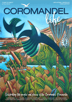
On the Whitianga Rock trail, the formidable
nature of the rock peninsula becomes obvious
as one sees the sheer face of it, with its
ominous cave openings.
Visible remnants of this well-fortified Ngati
Hei Pa stronghold date back perhaps 600
years. Three sides offered steep protective
cliffs, while the fourth side facing Back Bay
was fortified with ditches and earthen banks.
Despite the heavy defences, in the mid-
eighteenth century it was ransacked by a war
party of Ngai te Rangi.
You’ll notice several areas of exposed layers
of pipi shell middens, evidence of early Maori
occupation.
Other rock features may have served as fire
pits or water holes. Flat, grassy terraces were
used for housing, but the wind-eroded caves
were used as burial sites, thus are ‘tapu’ –
sacred and off limits to rock climbers.
The walk terminates at Ferry Landing Wharf,
the oldest stone wharf in Australasia and
listed with Historic Places. Built in 1837 by
local Maori from stones quarried from the
cliffs, the stone landing has been restored in
recent years.
November 9 1769, Captain James Cook and
astronomer Charles Green landed on the shore
of what is now Cooks Beach to observe a
Transit of Mercury.
Cook writes in his diary:
“Thursday, 9th.
Variable light breezes and clear weather. As
soon as it was daylight the natives began to
bring off Mackrell, and more than we well know
what to do with; notwithstanding I order’d
all they brought to be purchased in order to
encourage them in this kind of Traffick.
At 8, Mr. Green and I went on shore with our
Instruments to observe the Transit of Mercury.”
Days later, on 15 November, Cook would
raise the British Colours, claiming the area in
the name of King George III, and naming it
Mercury Bay.
In 1919, an area around Shakespeare Cliff was
set aside with a memorial. But the actual site
was found to be the eastern end of Cooks
Beach, near the Purangi estuary. A smaller
memorial plinth was established there also.
2019 will mark the 250th Anniversary of
Cook’s landing in NZ. Look forward to
extensive celebrations throughout the country.
The next transit of Mercury fully visible from
New Zealand will occur in 2052.
7 Grange Rd, Hahei
|
P. 07 866 3354
www.thepourhouse.nz“Fantastic!”
Great hosts serving us
with tasty craft beers
brewed onsite with pizza.
Well done guys.
COROMANDEL’S ORIGINAL BREWERY
JUST MINUTES FROM CATHEDRAL COVE
Ever Changing
Craft Beers
Made on Site
!
&
NZ Wines
Seasonally
Fresh Food
Beer Garden
open daily in summer
See Website for hours
The grassy knoll visible
is just below the summit
of Whitianga Rock.
Captain James Cook describes landings in the area
20
COROMANDEL LIFE 2017 LATE AUTUMN / WINTER
Photo by Alan Duff www.crep.co.nz